
Thank you for supporting this site ❤️
Make a donation
Make a donation
Col du Grand Ballon topographic map
Click on the map to display elevation.
Thank you for supporting this site ❤️
Make a donation
Make a donation
Col du Grand Ballon
La route des Crêtes contourne le sommet par l'est, franchissant un col à l'altitude de 1 341 mètres, entre le Markstein et le Hartmannswillerkopf (Vieil Armand).
Thank you for supporting this site ❤️
Make a donation
Make a donation
About this map
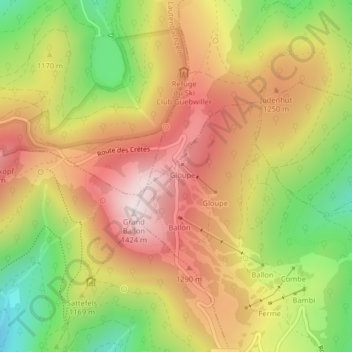
Name: Col du Grand Ballon topographic map, elevation, terrain.
Average elevation: 1,143 m
Minimum elevation: 820 m
Maximum elevation: 1,419 m
Thank you for supporting this site ❤️
Make a donation
Make a donation