
Thank you for supporting this site ❤️
Make a donation
Make a donation
Lake Forest topographic map
Click on the map to display elevation.
Thank you for supporting this site ❤️
Make a donation
Make a donation
About this map
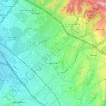
Name: Lake Forest topographic map, elevation, terrain.
Location: Lake Forest, Orange County, California, United States (33.60683 -117.72700 33.70688 -117.62017)
Average elevation: 193 m
Minimum elevation: 67 m
Maximum elevation: 565 m
Thank you for supporting this site ❤️
Make a donation
Make a donation
Other topographic maps
Click on a map to view its topography, its elevation and its terrain.
Leisure World
United States > California > Orange County > Seal Beach > Leisure World
Average elevation: 6 m