
Thank you for supporting this site ❤️
Make a donation
Make a donation
Ingleton topographic map
Click on the map to display elevation.
Thank you for supporting this site ❤️
Make a donation
Make a donation
About this map
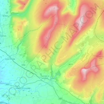
Name: Ingleton topographic map, elevation, terrain.
Location: Ingleton, North Yorkshire, England, United Kingdom (54.12331 -2.50878 54.25714 -2.28640)
Average elevation: 309 m
Minimum elevation: 39 m
Maximum elevation: 733 m
Thank you for supporting this site ❤️
Make a donation
Make a donation
Other topographic maps
Click on a map to view its topography, its elevation and its terrain.
Thank you for supporting this site ❤️
Make a donation
Make a donation
Thank you for supporting this site ❤️
Make a donation
Make a donation
Thank you for supporting this site ❤️
Make a donation
Make a donation
Swilla Glen
United Kingdom > England > North Yorkshire > Thornton in Lonsdale
Average elevation: 204 m
Thank you for supporting this site ❤️
Make a donation
Make a donation