
Make a donation
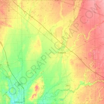
Shelby County topographic map
Click on the map to display elevation.
Make a donation
Shelby County
The low, rolling hills of Shelby County are lightly carved by drainages, but are otherwise completely devoted to agriculture or urban development. The western edge of the county is drained by Sugar Creek, flowing south-southwestward into Johnson County. The central and SW parts of the county are drained by Big Blue River, flowing south-southwestward into Johnson County. The lower part of the county is drained by Flatrock River, flowing southwestward into Bartholomew County. The terrain slopes to the southwest, with its highest elevations (930 feet/280 meters ASL) along the eastern part of its northern border with Hancock County. According to the 2010 census, the county has a total area of 412.76 square miles (1,069.0 km2), of which 411.15 square miles (1,064.9 km2) (or 99.61%) is land and 1.61 square miles (4.2 km2) (or 0.39%) is water.
Make a donation
About this map
Name: Shelby County topographic map, elevation, terrain.
Location: Shelby County, Indiana, United States (39.34737 -85.95303 39.69900 -85.62896)
Average elevation: 241 m
Minimum elevation: 197 m
Maximum elevation: 289 m
Make a donation
Other topographic maps
Click on a map to view its topography, its elevation and its terrain.