
Make a donation
St Leonards topographic map
Click on the map to display elevation.
Make a donation
About this map
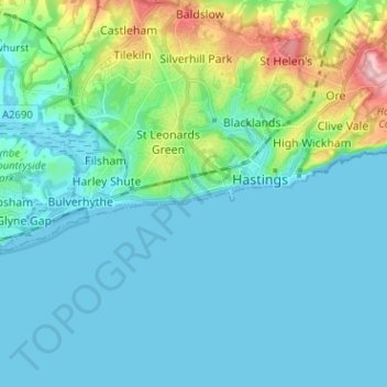
Name: St Leonards topographic map, elevation, terrain.
Average elevation: 30 m
Minimum elevation: -1 m
Maximum elevation: 173 m
Make a donation
Other topographic maps
Click on a map to view its topography, its elevation and its terrain.
Make a donation
Ouse Valley
United Kingdom > England > East Sussex > Newhaven > Mount Pleasant
Average elevation: 15 m
Make a donation
Highwoods SSSI
United Kingdom > England > East Sussex > Rother > Bexhill-on-Sea
Average elevation: 28 m
Bewl Water
United Kingdom > England > East Sussex > Rother District > Ticehurst
Average elevation: 92 m
Make a donation
Crowborough
United Kingdom > England > East Sussex > Wealden District
In the late 19th century, Crowborough was promoted as a health resort based on its high elevation, the rolling hills and surrounding forest. Estate Agents even called it "Scotland in Sussex". The town's golf course opened in 1895, followed by a fire station and hospital in 1900.
Average elevation: 146 m
Rye
United Kingdom > England > East Sussex > Rother
The town and its striking surroundings have frequently served as subject for painters, many of whose works are now on display in its art gallery. One of the earliest topographical panoramas, dating from the 17th century when the town was still an island port, is in the style of Hendrick Danckerts and on…
Average elevation: 7 m
Make a donation