
Taschkent topographic map
Interactive map
Click on the map to display elevation.
About this map
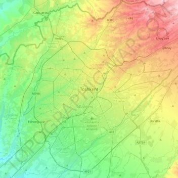
Name: Taschkent topographic map, elevation, terrain.
Location: Taschkent, Yakkasaroy Tumani, Taschkent, 100128, Usbekistan (41.15234 69.11871 41.47234 69.43871)
Average elevation: 447 m
Minimum elevation: 352 m
Maximum elevation: 629 m
Das Stadtgebiet von Taschkent hat eine Fläche von 334,8 Quadratkilometern. Dies entspricht etwas mehr als einem Drittel der Fläche Berlins. Die Stadt liegt in einer Höhe von etwa 455 Metern an den Westausläufern des Tianshangebirges. Der Fluss Ankhor durchfließt sie; an der südlichen Stadtgrenze verläuft von Nordosten kommend der Fluss Chirchiq.
Other topographic maps
Click on a map to view its topography, its elevation and its terrain.
Mirobod Tumani
Mirobod Tumani, Taschkent, 100000, Usbekistan
Average elevation: 439 m
Chilonzor Tumani
Chilonzor Tumani, Taschkent, 100000, Usbekistan
Average elevation: 424 m
Yangi hayot Tumani
Yangi hayot Tumani, Taschkent, 100000, Usbekistan
Average elevation: 395 m
Шайхантахурский район
Шайхантахурский район, Taschkent, 100000, Usbekistan
Average elevation: 676 m
Mirzo Ulug‘bek Tumani
Mirzo Ulug‘bek Tumani, Taschkent, 100000, Usbekistan
Average elevation: 784 m