
အုတ်ဖို topographic map
Interactive map
Click on the map to display elevation.
About this map
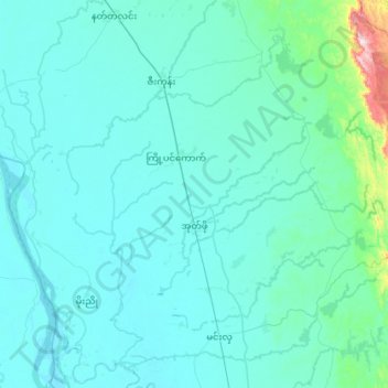
Name: အုတ်ဖို topographic map, elevation, terrain.
Average elevation: 57 m
Minimum elevation: 7 m
Maximum elevation: 783 m
Other topographic maps
Click on a map to view its topography, its elevation and its terrain.
Pégou
Birmanie > Bago > ပဲခူးခရိုင်
Pégou, ပဲခူးခရိုင်, ပဲခူးတိုင်းဒေသကြီး အရှေ့ခြမ်း, Bago, Birmanie
Average elevation: 42 m
ပဲခူးတိုင်းဒေသကြီး အနောက်ခြမ်း
ပဲခူးတိုင်းဒေသကြီး အနောက်ခြမ်း, Bago, Birmanie
Average elevation: 146 m