
Thank you for supporting this site ❤️
Make a donation
Make a donation
Frossos topographic map
Click on the map to display elevation.
Thank you for supporting this site ❤️
Make a donation
Make a donation
About this map
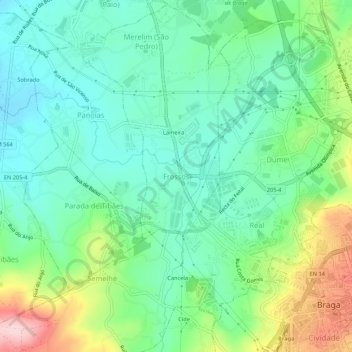
Name: Frossos topographic map, elevation, terrain.
Location: Frossos, Braga, 4710-154, Portugal (41.54560 -8.47118 41.58560 -8.43118)
Average elevation: 88 m
Minimum elevation: 22 m
Maximum elevation: 244 m
Thank you for supporting this site ❤️
Make a donation
Make a donation
Other topographic maps
Click on a map to view its topography, its elevation and its terrain.