
Thank you for supporting this site ❤️
Make a donation
Make a donation
Kikoni topographic map
Click on the map to display elevation.
Thank you for supporting this site ❤️
Make a donation
Make a donation
About this map
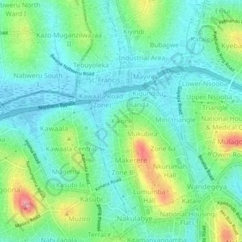
Name: Kikoni topographic map, elevation, terrain.
Location: Kikoni, Kampala, Uganda (0.32422 32.54127 0.36422 32.58127)
Average elevation: 1,194 m
Minimum elevation: 1,162 m
Maximum elevation: 1,273 m
Thank you for supporting this site ❤️
Make a donation
Make a donation
Other topographic maps
Click on a map to view its topography, its elevation and its terrain.