
Thank you for supporting this site ❤️
Make a donation
Make a donation
Catterick topographic map
Click on the map to display elevation.
Thank you for supporting this site ❤️
Make a donation
Make a donation
About this map
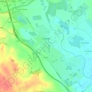
Name: Catterick topographic map, elevation, terrain.
Location: Catterick, North Yorkshire, England, United Kingdom (54.35706 -1.66072 54.39217 -1.60390)
Average elevation: 61 m
Minimum elevation: 40 m
Maximum elevation: 103 m
Thank you for supporting this site ❤️
Make a donation
Make a donation
Other topographic maps
Click on a map to view its topography, its elevation and its terrain.
Thank you for supporting this site ❤️
Make a donation
Make a donation
Thank you for supporting this site ❤️
Make a donation
Make a donation
Thank you for supporting this site ❤️
Make a donation
Make a donation
Swilla Glen
United Kingdom > England > North Yorkshire > Thornton in Lonsdale
Average elevation: 204 m
Thank you for supporting this site ❤️
Make a donation
Make a donation