
Obergrünbach topographic map
Interactive map
Click on the map to display elevation.
About this map
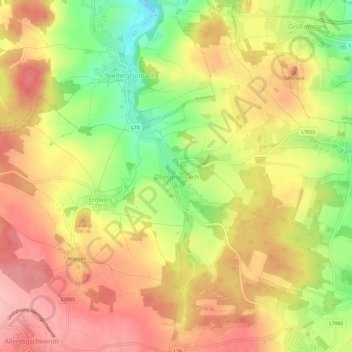
Name: Obergrünbach topographic map, elevation, terrain.
Average elevation: 663 m
Minimum elevation: 585 m
Maximum elevation: 720 m
Other topographic maps
Click on a map to view its topography, its elevation and its terrain.
Lichtenau
Österreich > Niederösterreich > Bezirk Krems > Gemeinde Lichtenau im Waldviertel
Lichtenau, Gemeinde Lichtenau im Waldviertel, Bezirk Krems, Niederösterreich, 3522, Österreich
Average elevation: 642 m