
Agoo-Damortis Protected Landscape and Seascape topographic map
Interactive map
Click on the map to display elevation.
About this map
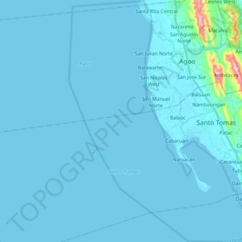
Name: Agoo-Damortis Protected Landscape and Seascape topographic map, elevation, terrain.
Average elevation: 9 m
Minimum elevation: -1 m
Maximum elevation: 246 m
Other topographic maps
Click on a map to view its topography, its elevation and its terrain.
Sungyot Island
Philippines > La Union > Santo Tomas
Sungyot Island, Santo Tomas, La Union, Ilocos Region, Philippines
Average elevation: 0 m
Cupang
Philippines > La Union > Santo Tomas
Cupang, Santo Tomas, La Union, Ilocos Region, Philippines
Average elevation: 23 m
Tubod
Philippines > La Union > Santo Tomas
Tubod, Santo Tomas, La Union, Ilocos Region, Philippines
Average elevation: 24 m
Damortis
Philippines > La Union > Santo Tomas
Damortis, Santo Tomas, La Union, Philippines
Average elevation: 25 m
Parasapas
Philippines > La Union > Santo Tomas
Parasapas, Santo Tomas, La Union, Ilocos Region, 2508, Philippines
Average elevation: 202 m
Santo Tomas
Philippines > La Union > Santo Tomas
Santo Tomas, La Union, Ilocos Region, 2505, Philippines
Average elevation: 40 m