
Paterson topographic map
Interactive map
Click on the map to display elevation.
About this map
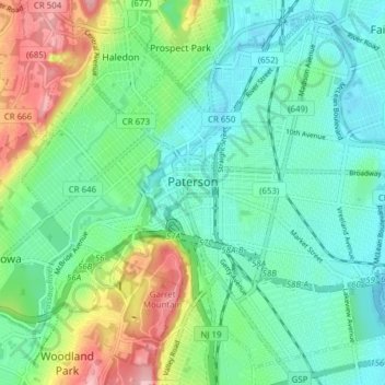
Name: Paterson topographic map, elevation, terrain.
Location: Paterson, Passaic County, New Jersey, États-Unis d'Amérique (40.88868 -74.20620 40.94159 -74.12923)
Average elevation: 54 m
Minimum elevation: 9 m
Maximum elevation: 163 m
Other topographic maps
Click on a map to view its topography, its elevation and its terrain.
Passaic
États-Unis d'Amérique > New Jersey > Passaic County > Passaic
Passaic, Passaic County, New Jersey, 07055, États-Unis d'Amérique
Average elevation: 31 m
Paterson
États-Unis d'Amérique > New Jersey > Passaic County > Paterson
Paterson, Passaic County, New Jersey, 07505, États-Unis d'Amérique
Average elevation: 74 m
Haledon
États-Unis d'Amérique > New Jersey > Passaic County > Haledon
Haledon, Passaic County, New Jersey, États-Unis d'Amérique
Average elevation: 81 m