
Thank you for supporting this site ❤️
Make a donation
Make a donation
Centerville topographic map
Click on the map to display elevation.
Thank you for supporting this site ❤️
Make a donation
Make a donation
About this map
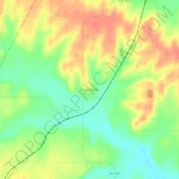
Name: Centerville topographic map, elevation, terrain.
Location: Centerville, Linn County, Kansas, 66014, United States (38.20086 -95.03414 38.24086 -94.99414)
Average elevation: 287 m
Minimum elevation: 260 m
Maximum elevation: 312 m
Thank you for supporting this site ❤️
Make a donation
Make a donation