
Speikboden topographic map
Interactive map
Click on the map to display elevation.
About this map
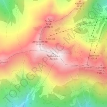
Name: Speikboden topographic map, elevation, terrain.
Average elevation: 2,120 m
Minimum elevation: 1,622 m
Maximum elevation: 2,508 m
Other topographic maps
Click on a map to view its topography, its elevation and its terrain.
Sand in Taufers - Campo Tures
Italië > Trentino-Zuid-Tirol > Bolzano - Bozen > Sand in Taufers - Campo Tures
Sand in Taufers - Campo Tures, Pustertal - Val Pusteria, Bolzano - Bozen, Trentino-Zuid-Tirol, 39032, Italië
Average elevation: 1,973 m