
Lava Hot Springs topographic map
Interactive map
Click on the map to display elevation.
About this map
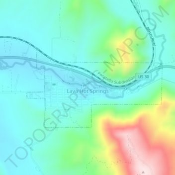
Name: Lava Hot Springs topographic map, elevation, terrain.
Average elevation: 1,611 m
Minimum elevation: 1,516 m
Maximum elevation: 1,896 m
Lava Hot Springs is located at 42°37′10″N 112°0′51″W / 42.61944°N 112.01417°W / 42.61944; -112.01417 (42.619482, -112.014283), at an elevation of 5,020 feet (1,530 m) above sea level.
Other topographic maps
Click on a map to view its topography, its elevation and its terrain.
Fort Hall
United States > Idaho > Bannock County
Fort Hall, Bannock County, Idaho, United States
Average elevation: 1,377 m
Pocatello
United States > Idaho > Bannock County
Pocatello, Bannock County, Idaho, United States
Average elevation: 1,580 m