
Pill topographic map
Click on the map to display elevation.
About this map
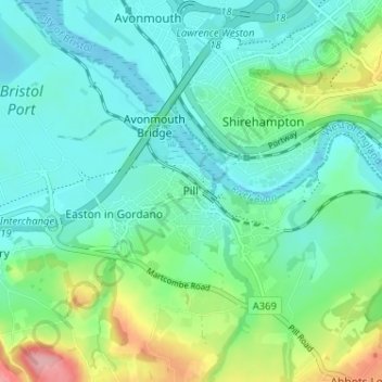
Name: Pill topographic map, elevation, terrain.
Location: Pill, North Somerset, England, BS20 0DA, United Kingdom (51.46082 -2.70836 51.50082 -2.66836)
Average elevation: 31 m
Minimum elevation: -6 m
Maximum elevation: 129 m
Other topographic maps
Click on a map to view its topography, its elevation and its terrain.
Portishead Quays Marina
United Kingdom > England > North Somerset > Portishead > North Weston
Average elevation: 11 m