
Konmaru La East topographic map
Interactive map
Click on the map to display elevation.
About this map
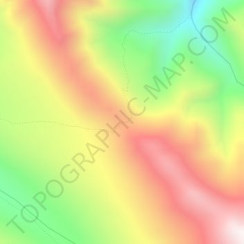
Name: Konmaru La East topographic map, elevation, terrain.
Location: Konmaru La East, Leh Tehsil, Distrikt Leh, Ladakh, Indien (33.78039 77.60739 33.80039 77.62739)
Average elevation: 5,100 m
Minimum elevation: 4,637 m
Maximum elevation: 5,537 m
Other topographic maps
Click on a map to view its topography, its elevation and its terrain.
Indus
Indien > Ladakh > Leh Tehsil
Indus, Leh Tehsil, Distrikt Leh, Ladakh, Indien
Average elevation: 4,192 m
Hemis
Indien > Ladakh > Leh Tehsil
Hemis, Leh Tehsil, Distrikt Leh, Ladakh, Indien
Average elevation: 5,218 m
Leh
Indien > Ladakh > Leh Tehsil
Leh, Leh Tehsil, Distrikt Leh, Ladakh, Indien
Average elevation: 3,653 m