
Aveley topographic map
Interactive map
Click on the map to display elevation.
About this map
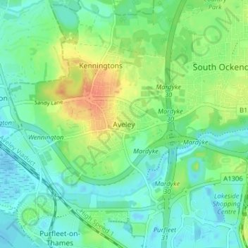
Name: Aveley topographic map, elevation, terrain.
Location: Aveley, Thurrock, Essex, Engeland, RM15 4TJ, Verenigd Koninkrijk (51.48011 0.23618 51.52011 0.27618)
Average elevation: 13 m
Minimum elevation: -13 m
Maximum elevation: 39 m
Other topographic maps
Click on a map to view its topography, its elevation and its terrain.
Grays
Verenigd Koninkrijk > Engeland > Essex
Grays, Thurrock, Essex, Engeland, RM17 5DD, Verenigd Koninkrijk
Average elevation: 14 m
Billericay
Verenigd Koninkrijk > Engeland > Essex
Billericay, Basildon, Essex, Engeland, Verenigd Koninkrijk
Average elevation: 63 m
Mill End
Verenigd Koninkrijk > Engeland > Essex > Uttlesford > Molehill Green > Mill End
Mill End, Takeley, Molehill Green, Uttlesford, Essex, East of England, Engeland, CM22 6PL, Verenigd Koninkrijk
Average elevation: 101 m