
Thank you for supporting this site ❤️
Make a donation
Make a donation
Cisarua topographic map
Click on the map to display elevation.
Thank you for supporting this site ❤️
Make a donation
Make a donation
Cisarua
The district is known for its mild climate, tea fields, and extensive views, being located in a rather high altitude. Near the district is a mountain pass known for its villas, hostels, as well as a well-known "heritage" hotel known as the "Puncak Pass", built in 1928.
Thank you for supporting this site ❤️
Make a donation
Make a donation
About this map
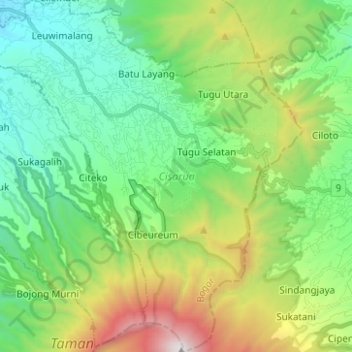
Name: Cisarua topographic map, elevation, terrain.
Location: Cisarua, Bogor, West Java, Java, 16750, Indonesia (-6.77032 106.89486 -6.64657 107.00683)
Average elevation: 1,310 m
Minimum elevation: 592 m
Maximum elevation: 2,999 m
Thank you for supporting this site ❤️
Make a donation
Make a donation