
Attendorn topographic map
Interactive map
Click on the map to display elevation.
About this map
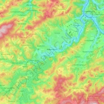
Name: Attendorn topographic map, elevation, terrain.
Location: Attendorn, Kreis Olpe, Noordrijn-Westfalen, 57439, Duitsland (51.07271 7.79579 51.17069 8.00401)
Average elevation: 384 m
Minimum elevation: 229 m
Maximum elevation: 630 m
Other topographic maps
Click on a map to view its topography, its elevation and its terrain.
Altenhundem
Duitsland > Noordrijn-Westfalen > Kreis Olpe > Lennestadt
Altenhundem, Lennestadt, Kreis Olpe, Noordrijn-Westfalen, 57368, Duitsland
Average elevation: 377 m
Kruberg
Duitsland > Noordrijn-Westfalen > Kreis Olpe > Olpe
Kruberg, Olpe, Kreis Olpe, Noordrijn-Westfalen, Duitsland
Average elevation: 440 m