
Ursel topographic map
Interactive map
Click on the map to display elevation.
About this map
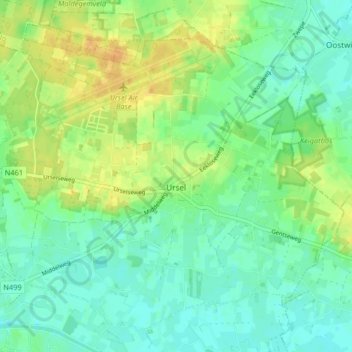
Name: Ursel topographic map, elevation, terrain.
Location: Ursel, Aalter, Gent, East Flanders, Flanders, Belgium (51.10936 3.44272 51.15395 3.52459)
Average elevation: 14 m
Minimum elevation: 3 m
Maximum elevation: 31 m
Other topographic maps
Click on a map to view its topography, its elevation and its terrain.
Knesselare
Belgium > East Flanders > Gent > Aalter
Knesselare, Aalter, Gent, East Flanders, Flanders, 9910, Belgium
Average elevation: 12 m