
Prüm topographic map
Interactive map
Click on the map to display elevation.
About this map
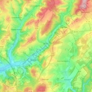
Name: Prüm topographic map, elevation, terrain.
Average elevation: 494 m
Minimum elevation: 392 m
Maximum elevation: 628 m
Die Stadt Prüm liegt am Fluss Prüm (Nebenfluss der Sauer) am Fuß des Schneifel-Höhenzuges zwischen Ardennen und Eifel in einer Höhe von 420 bis 560 m ü. NHN (St.-Joseph-Krankenhaus). Die Stadt ist namensgebend für die größte der devonischen Kalkmulden der Eifel, die 240 km2 große Prümer Kalkmulde.
Other topographic maps
Click on a map to view its topography, its elevation and its terrain.
Spangdahlem
Deutschland > Rheinland-Pfalz > Eifelkreis Bitburg-Prüm
Spangdahlem, Speicher, Eifelkreis Bitburg-Prüm, Rheinland-Pfalz, 54529, Deutschland
Average elevation: 333 m
Bettingen
Deutschland > Rheinland-Pfalz > Eifelkreis Bitburg-Prüm
Bettingen, Bitburger Land, Eifelkreis Bitburg-Prüm, Rheinland-Pfalz, 54646, Deutschland
Average elevation: 302 m
Irrhausen
Deutschland > Rheinland-Pfalz > Eifelkreis Bitburg-Prüm
Irrhausen, Arzfeld, Eifelkreis Bitburg-Prüm, Rheinland-Pfalz, Deutschland
Average elevation: 443 m
Winterscheid
Deutschland > Rheinland-Pfalz > Eifelkreis Bitburg-Prüm
Winterscheid, Prüm, Eifelkreis Bitburg-Prüm, Rheinland-Pfalz, Deutschland
Average elevation: 487 m
Seimerich
Deutschland > Rheinland-Pfalz > Eifelkreis Bitburg-Prüm
Seimerich, Körperich, Südeifel, Eifelkreis Bitburg-Prüm, Rheinland-Pfalz, 54675, Deutschland
Average elevation: 289 m
Heckhalenfeld
Deutschland > Rheinland-Pfalz > Eifelkreis Bitburg-Prüm > Winterspelt
Heckhalenfeld, Winterspelt, Prüm, Eifelkreis Bitburg-Prüm, Rheinland-Pfalz, 54616, Deutschland
Average elevation: 480 m
Mützenich
Deutschland > Rheinland-Pfalz > Eifelkreis Bitburg-Prüm
Mützenich, Prüm, Eifelkreis Bitburg-Prüm, Rheinland-Pfalz, Deutschland
Average elevation: 507 m
Schweiler
Deutschland > Rheinland-Pfalz > Eifelkreis Bitburg-Prüm > Mützenich
Schweiler, Mützenich, Prüm, Eifelkreis Bitburg-Prüm, Rheinland-Pfalz, Deutschland
Average elevation: 498 m
Gemünd
Deutschland > Rheinland-Pfalz > Eifelkreis Bitburg-Prüm > Gemünd
Gemünd, Südeifel, Eifelkreis Bitburg-Prüm, Rheinland-Pfalz, Deutschland
Average elevation: 341 m