
Socorro topographic map
Interactive map
Click on the map to display elevation.
About this map
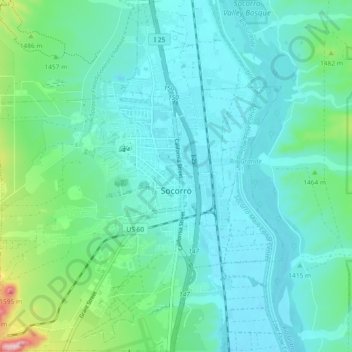
Name: Socorro topographic map, elevation, terrain.
Location: Socorro, Socorro County, New Mexico, United States (34.02234 -106.93959 34.09858 -106.86510)
Average elevation: 1,433 m
Minimum elevation: 1,393 m
Maximum elevation: 1,615 m
Socorro (/səˈkɔːroʊ/, sə-KOR-oh) is a city in Socorro County in the U.S. state of New Mexico. It is in the Rio Grande Valley at an elevation of 4,579 feet (1,396 m). In 2010 the population was 9,051. It is the county seat of Socorro County. Socorro is located 74 miles (119 km) south of Albuquerque and 146 miles (235 km) north of Las Cruces.
Other topographic maps
Click on a map to view its topography, its elevation and its terrain.
San Mateo Mountain
United States > New Mexico > Socorro County
San Mateo Mountain, Socorro County, New Mexico, United States
Average elevation: 2,731 m
Tokay
United States > New Mexico > Socorro County > Tokay
Tokay, Socorro County, New Mexico, United States
Average elevation: 1,546 m