
Thank you for supporting this site ❤️
Make a donation
Make a donation
Norfolk topographic map
Click on the map to display elevation.
Thank you for supporting this site ❤️
Make a donation
Make a donation
About this map
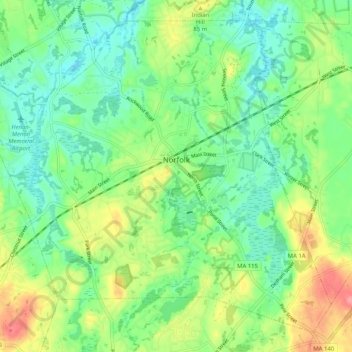
Name: Norfolk topographic map, elevation, terrain.
Location: Norfolk, Norfolk County, Massachusetts, 02056, United States (42.08239 -71.38217 42.14950 -71.28027)
Average elevation: 64 m
Minimum elevation: 33 m
Maximum elevation: 121 m
Thank you for supporting this site ❤️
Make a donation
Make a donation
Other topographic maps
Click on a map to view its topography, its elevation and its terrain.
Thank you for supporting this site ❤️
Make a donation
Make a donation
Thank you for supporting this site ❤️
Make a donation
Make a donation
Braintree Highlands
United States > Massachusetts > Norfolk County > Braintree
Average elevation: 46 m
Thank you for supporting this site ❤️
Make a donation
Make a donation
Thank you for supporting this site ❤️
Make a donation
Make a donation
Braintree
United States > Massachusetts > Norfolk County > Braintree > Braintree
Average elevation: 39 m
Thank you for supporting this site ❤️
Make a donation
Make a donation
City Mills
United States > Massachusetts > Norfolk County > Norfolk > City Mills
Average elevation: 66 m
Thank you for supporting this site ❤️
Make a donation
Make a donation