
Aínsa topographic map
Interactive map
Click on the map to display elevation.
About this map
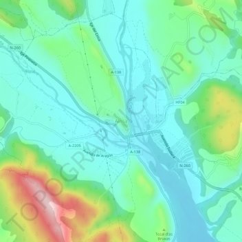
Name: Aínsa topographic map, elevation, terrain.
Location: Aínsa, Aínsa-Sobrarbe, Sobrarbe, Huesca, Aragón, 22330, España (42.39719 0.11864 42.43719 0.15864)
Average elevation: 596 m
Minimum elevation: 514 m
Maximum elevation: 842 m
Other topographic maps
Click on a map to view its topography, its elevation and its terrain.
Latorrecilla
España > Aragón > Sobrarbe > Aínsa-Sobrarbe
Latorrecilla, Aínsa-Sobrarbe, Sobrarbe, Huesca, Aragón, 22349, España
Average elevation: 676 m