
Jimla topographic map
Interactive map
Click on the map to display elevation.
About this map
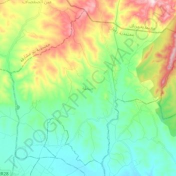
Name: Jimla topographic map, elevation, terrain.
Location: Jimla, Zaghouan, Tunisie (36.42270 10.13479 36.51914 10.27082)
Average elevation: 224 m
Minimum elevation: 93 m
Maximum elevation: 512 m
Other topographic maps
Click on a map to view its topography, its elevation and its terrain.
Djebel Zaghouan
Djebel Zaghouan, Bir Halima, Zaghouan, Tunisie
Average elevation: 760 m
Bir Mcherga
Tunisie > Zaghouan > Bir Mcherga
Bir Mcherga, Bir M'chergua, Bir Mchergua, Zaghouan, 1141, Tunisie
Average elevation: 156 m
Barrage de Errmal
Barrage de Errmal, RR 35 طج, Bouachir, Bou Achir, Ez-Zeriba, Zaghouan, Tunisie
Average elevation: 55 m
Barrage el Kebir
Barrage el Kebir, RN 4 طو, Eddroua, El Fahs, Zaghouan, Tunisie
Average elevation: 359 m