
Make a donation
Kupang topographic map
Click on the map to display elevation.
Make a donation
Kupang
Kupang is located in the southwestern tip of the island of Timor. It is solely bordered by the Kupang Regency on land, and on its northern shore by the Savu Sea. It has a land area of 180.27 square kilometers (which is divided into six administrative districts), along with a water area of 94.79 square kilometers. The area around the city is geologically inactive, with soil composition characterised by non-volcanic materials such as Latosol and Terra rossa. At its highest point, the city is 62 metres above sea level, with inclination varying from 0 - 5%. The topography of the city is mostly low-lying, but also includes groups of hills in the south and southwest, which has the effect of creating a relatively fertile catchment area.
Make a donation
About this map
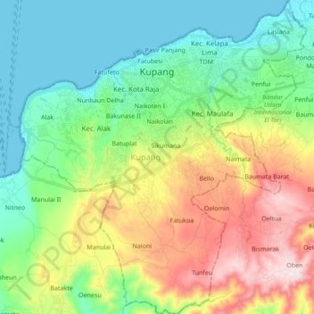
Name: Kupang topographic map, elevation, terrain.
Location: Kupang, East Nusa Tenggara, Indonesia (-10.29279 123.52707 -10.12510 123.68317)
Average elevation: 168 m
Minimum elevation: 0 m
Maximum elevation: 503 m
Make a donation