
Tampa topographic map
Interactive map
Click on the map to display elevation.
About this map
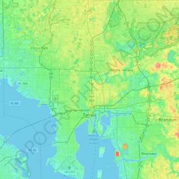
Name: Tampa topographic map, elevation, terrain.
Location: Tampa, Hillsborough County, Floride, États-Unis d'Amérique (27.82126 -82.58650 28.17136 -82.25387)
Average elevation: 11 m
Minimum elevation: -3 m
Maximum elevation: 45 m
Other topographic maps
Click on a map to view its topography, its elevation and its terrain.
Alexandria Place
États-Unis d'Amérique > Floride > Hillsborough County
Alexandria Place, Hillsborough County, Floride, 33619, États-Unis d'Amérique
Average elevation: 13 m
Altos Verdes
États-Unis d'Amérique > Floride > Hillsborough County > Tampa
Altos Verdes, Tampa, Hillsborough County, Floride, 33617, États-Unis d'Amérique
Average elevation: 15 m