Geolocate

Camarillo topographic map

Interactive map

Click on the map to display elevation.

About this map

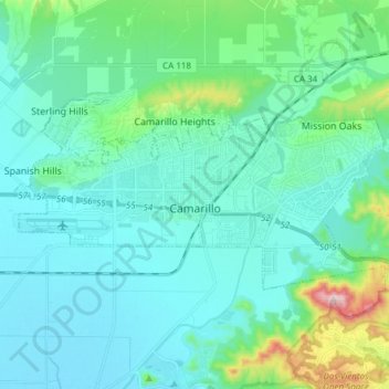
Name: Camarillo topographic map, elevation, terrain.

Location: Camarillo, Ventura County, California, United States (34.19130 -119.10945 34.25267 -118.95790)

Average elevation: 90 m

Minimum elevation: 6 m

Maximum elevation: 545 m

In the mid-1950s, the Ventura Freeway was completed from Los Angeles to points north, making it an easy one-hour trip to Camarillo. The Old Town was bisect by the Ventura Freeway. On the southern side of the freeway contains a strip of businesses, churches, schools, and parks. The freeway was originally planned to follow the path of Potrero Road, south of Camarillo, which would have completely by-passed the soon-to-be city. However, after much debate, city officials persuaded Caltrans to lay the freeway parallel to Ventura Boulevard, creating the infamously steep descent from the Santa Monica Mountains, known as the Conejo Grade. The grade is about 2.7 miles (4.3 km) and posted as a 7% grade—which translates as about one thousand feet of elevation change in less than three miles (70 meters per kilometer). There is a California Highway Patrol brake inspection station at the top of the grade and a stop is mandatory for all 18-wheel trucks. The completion of the freeway facilitated the growth that followed. In 1962, the population was 7,500 and 3M began construction for the Mincom and Magnetic Tape Divisions, which would ultimately employ 900 people, becoming the largest local employer. That plant briefly housed a factory for 3M spinoff Imation before being closed in 2008.

Wikipedia (CC-BY-SA 3.0)

Other topographic maps

Click on a map to view its topography, its elevation and its terrain.

Oxnard

United States > California > Ventura County

Oxnard, Ventura County, California, United States

Average elevation: 16 m

Thousand Oaks

United States > California > Ventura County > Thousand Oaks

Thousand Oaks, Ventura County, California, United States

Average elevation: 303 m

Newbury Park

United States > California > Ventura County > Thousand Oaks

Newbury Park, Thousand Oaks, Ventura County, CAL Fire Southern Region, California, 91320, United States

Average elevation: 262 m

CSUCI Repeater Station

United States > California > Ventura County

CSUCI Repeater Station, Ventura County, California, 93012, United States

Average elevation: 50 m

Oak Park

United States > California > Ventura County

Oak Park, Ventura County, California, 91377, United States

Average elevation: 393 m

San Buenaventura (Ventura)

United States > California > Ventura County

San Buenaventura (Ventura), Ventura County, California, United States

Average elevation: 163 m

Haines

United States > California > Ventura County

Haines, Ventura County, California, 93060, United States

Average elevation: 89 m

Simi Valley

United States > California > Ventura County

Simi Valley, Ventura County, California, United States

Average elevation: 405 m

Mira Monte

United States > California > Ventura County

Mira Monte, Ventura County, California, United States

Average elevation: 221 m

Moorpark

United States > California > Ventura County

Moorpark, Ventura County, California, 93021, United States

Average elevation: 219 m

Channel Islands Beach

United States > California > Ventura County

Channel Islands Beach, Ventura County, California, United States

Average elevation: 3 m

Montalvo

United States > California > Ventura County > Ventura

Montalvo, Ventura, Ventura County, CAL Fire Southern Region, California, 93009, United States

Average elevation: 42 m

Paseo del Sol

United States > California > Ventura County > Simi Valley

Paseo del Sol, Simi Valley, Ventura County, California, 90363, United States

Average elevation: 333 m

Thousand Oaks

United States > California > Ventura County > Thousand Oaks

Thousand Oaks, Ventura County, California, 91362, United States

Average elevation: 288 m

Quatal Canyon

United States > California > Ventura County

Quatal Canyon, Ventura County, CAL Fire Southern Region, California, United States

Average elevation: 1,286 m

Fillmore

United States > California > Ventura County

Fillmore, Ventura County, CAL Fire Contract Counties, California, 93016, United States

Average elevation: 193 m

Santa Paula

United States > California > Ventura County

Santa Paula, Ventura County, CAL Fire Southern Region, California, United States

Average elevation: 148 m

Ventura

United States > California > Ventura County

Ventura, Ventura County, California, United States

Average elevation: 120 m

Kenney Grove Park

United States > California > Ventura County

Kenney Grove Park, Ventura County, CAL Fire Southern Region, California, 93016, United States

Average elevation: 192 m

Thousand Oaks

United States > California > Ventura County

Thousand Oaks, Ventura County, California, United States

Average elevation: 333 m

Whiteface

United States > California > Ventura County

Whiteface, Ventura County, CAL Fire Southern Region, California, 90363, United States

Average elevation: 517 m

Point Mugu State Park

United States > California > Ventura County

Point Mugu State Park, Ventura County, CAL Fire Southern Region, California, United States

Average elevation: 158 m

Ojai

United States > California > Ventura County

Ojai, Ventura County, California, 93023, United States

Average elevation: 289 m

Junipero Serra Park

United States > California > Ventura County > Ventura

Junipero Serra Park, Ventura, Ventura County, CAL Fire Southern Region, California, United States

Average elevation: 49 m

Greenwich Village

United States > California > Ventura County > Thousand Oaks

Greenwich Village, Thousand Oaks, Ventura County, CAL Fire Southern Region, California, 91360, United States

Average elevation: 275 m

Buckhorn

United States > California > Ventura County

Buckhorn, Ventura County, California, United States

Average elevation: 223 m

Oak Park

United States > California > Ventura County

Oak Park, Ventura County, California, 91377, United States

Average elevation: 378 m

San Buenaventura (Ventura)

United States > California > Ventura County

San Buenaventura (Ventura), Ventura County, CAL Fire Southern Region, California, United States

Average elevation: 158 m

Westlake Village

United States > California > Ventura County > Thousand Oaks

Westlake Village, Thousand Oaks, Ventura County, CAL Fire Southern Region, California, 91361, United States

Average elevation: 305 m

Hollywood Beach

United States > California > Ventura County

Hollywood Beach, Ventura County, CAL Fire Southern Region, California, 93035, United States

Average elevation: 3 m

Matilija

United States > California > Ventura County > Ojai

Matilija, Ojai, Ventura County, CAL Fire Southern Region, California, 93023, United States

Average elevation: 241 m

Ventu Park

United States > California > Ventura County > Thousand Oaks > Newbury Park

Ventu Park, Newbury Park, Thousand Oaks, Ventura County, CAL Fire Southern Region, California, 91320, United States

Average elevation: 250 m

Oxnard

United States > California > Ventura County > Oxnard

Oxnard, Ventura County, California, 93031, United States

Average elevation: 69 m

Virginia Colony

United States > California > Ventura County > Moorpark

Virginia Colony, Moorpark, Ventura County, CAL Fire Southern Region, California, 93021, United States

Average elevation: 219 m

La Conchita

United States > California > Ventura County

La Conchita, Ventura County, CAL Fire Southern Region, California, United States

Average elevation: 121 m

Fairview

United States > California > Ventura County

Fairview, Ventura County, CAL Fire Southern Region, California, United States

Average elevation: 280 m

Castlewood at Big Sky

United States > California > Ventura County > Simi Valley > Castlewood at Big Sky

Castlewood at Big Sky, Simi Valley, Ventura County, California, 93065-6278, United States

Average elevation: 360 m

Casitas Springs

United States > California > Ventura County > Ventura > Casitas Springs

Casitas Springs, Ventura, Ventura County, California, 93022, United States

Average elevation: 182 m

Lake Piru

United States > California > Ventura County

Lake Piru, Ventura County, CAL Fire Southern Region, California, United States

Average elevation: 375 m

Fillmore

United States > California > Ventura County

Fillmore, Ventura County, California, 93016, United States

Average elevation: 181 m

Saticoy

United States > California > Ventura County > Saticoy

Saticoy, Ventura County, California, 93004, United States

Average elevation: 55 m

Oak View

United States > California > Ventura County

Oak View, Ventura County, California, 93022, United States

Average elevation: 184 m

San Nicolas Island

United States > California > Ventura County

San Nicolas Island, Ventura County, CAL Fire Southern Region, California, United States

Average elevation: 38 m

Port Hueneme

United States > California > Ventura County

Port Hueneme, Ventura County, California, United States

Average elevation: 7 m