
Lot-et-Garonne topographic map
Interactive map
Click on the map to display elevation.
About this map
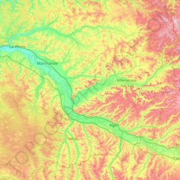
Name: Lot-et-Garonne topographic map, elevation, terrain.
Location: Lot-et-Garonne, Nouvelle-Aquitaine, Metropolitan France, France (43.97267 -0.14058 44.76568 1.07848)
Average elevation: 116 m
Minimum elevation: 6 m
Maximum elevation: 312 m
Other topographic maps
Click on a map to view its topography, its elevation and its terrain.