
Parc national de Chambi topographic map
Interactive map
Click on the map to display elevation.
About this map
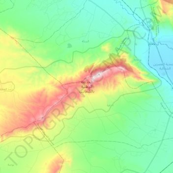
Name: Parc national de Chambi topographic map, elevation, terrain.
Average elevation: 907 m
Minimum elevation: 633 m
Maximum elevation: 1,534 m
Other topographic maps
Click on a map to view its topography, its elevation and its terrain.
Djebel Chambi
Tunisie > Gouvernorat Kasserine > Eddoghra
Djebel Chambi, Eddoghra, Délégation Kasserine Sud, Gouvernorat Kasserine, Tunisie
Average elevation: 1,261 m