
Make a donation
Sanafir Island topographic map
Click on the map to display elevation.
Make a donation
About this map
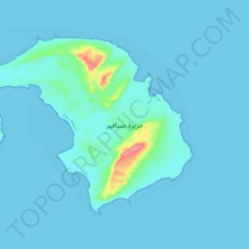
Name: Sanafir Island topographic map, elevation, terrain.
Average elevation: 7 m
Minimum elevation: 0 m
Maximum elevation: 106 m
Make a donation
Other topographic maps
Click on a map to view its topography, its elevation and its terrain.
Neom
On 3 March 2022, the Trojena project was launched, which will potentially be the first major outdoor skiing destination in the Arabian Peninsula. The project's site is about 50 kilometres (31 mi) from the Gulf of Aqaba coast in the Sarat Mountains, with elevations ranging from 1,500–2,600 metres…
Average elevation: 52 m
Make a donation
Make a donation
Neom
On 3 March 2022, Saudi Crown Prince Mohammed bin Salman launched the Trojena project, which will be the first major outdoor skiing destination in the Arabian Peninsula. It will be located about 50 kilometres (31 mi) from the Gulf of Aqaba coast, in the Sarwat Mountains, with elevations ranging from…
Average elevation: 52 m
Make a donation
Jabal al Lawz
Between 1300 and 2200 meters elevation, Jabal al-Lawz has relict Mediterranean woodlands of Juniperus phoenicea, with an understory of Achillea santolinoides, Artemisia sieberi, and Astracantha echinus subsp. arabica.
Average elevation: 1,993 m
Make a donation
Jabal al Lawz
Between 1300 and 2200 meters elevation, Jabal al-Lawz has relict Mediterranean woodlands of Juniperus phoenicea, with an understory of Achillea santolinoides, Artemisia sieberi, and Astracantha echinus subsp. arabica.
Average elevation: 1,993 m
Make a donation