
Make a donation
Yilan County topographic map
Click on the map to display elevation.
Make a donation
Yilan County
Yilan County is located in the northeastern Taiwan Island which covers an area of 2,143 km2. The longest distance from east to west is 63 km and from north to south is 74 km. From the mountain areas downwards, the land falls in altitude in the stages of mountains, alleys, alluvial plains, lowlands, swamps, sand hills and finally coastline.
Make a donation
About this map
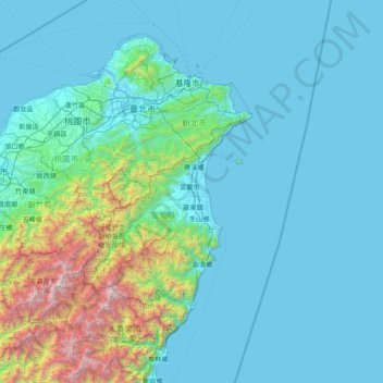
Name: Yilan County topographic map, elevation, terrain.
Location: Yilan County, 26060, Taiwan (24.03028 121.06311 25.43028 122.46311)
Average elevation: 416 m
Minimum elevation: -2 m
Maximum elevation: 3,838 m
Make a donation
Other topographic maps
Click on a map to view its topography, its elevation and its terrain.
Yilan City
Yilan City is located on Lanyang Plain with an average altitude of 7.38 meters above sea level.
Average elevation: 10 m