
Tutong District topographic map
Interactive map
Click on the map to display elevation.
About this map
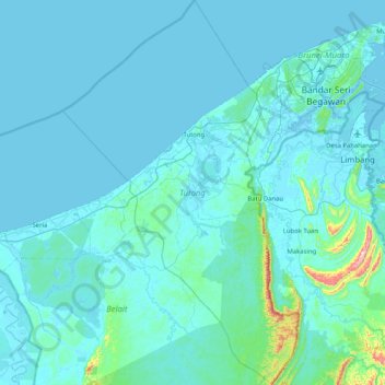
Name: Tutong District topographic map, elevation, terrain.
Location: Tutong District, Brunei (4.27349 114.34997 5.09263 114.88383)
Average elevation: 32 m
Minimum elevation: -4 m
Maximum elevation: 631 m
Other topographic maps
Click on a map to view its topography, its elevation and its terrain.
Limau Manis
Limau Manis, Mukim Pangkalan Batu, Brunei-Muara District, Brunei
Average elevation: 14 m
Bandar Seri Begawan
Bandar Seri Begawan, Mukim Kianggeh, Brunei-Muara District, BS8711, Brunei
Average elevation: 12 m