
Poti topographic map
Interactive map
Click on the map to display elevation.
About this map
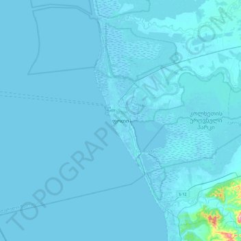
Name: Poti topographic map, elevation, terrain.
Location: Poti, Mingrélie-et-Haute-Svanétie, 4400, Géorgie (41.98161 41.51480 42.30161 41.83480)
Average elevation: 4 m
Minimum elevation: -3 m
Maximum elevation: 239 m
Other topographic maps
Click on a map to view its topography, its elevation and its terrain.
Poti
Géorgie > Mingrélie-et-Haute-Svanétie > Poti
Poti, ფოთი, Mingrélie-et-Haute-Svanétie, 4400, Géorgie
Average elevation: 1 m