
Thank you for supporting this site ❤️
Make a donation
Make a donation
Grandview topographic map
Click on the map to display elevation.
Thank you for supporting this site ❤️
Make a donation
Make a donation
About this map
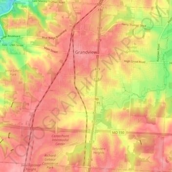
Name: Grandview topographic map, elevation, terrain.
Location: Grandview, Jackson County, Missouri, 64030, United States (38.84173 -94.56384 38.91058 -94.48857)
Average elevation: 304 m
Minimum elevation: 242 m
Maximum elevation: 333 m
Thank you for supporting this site ❤️
Make a donation
Make a donation
Other topographic maps
Click on a map to view its topography, its elevation and its terrain.
Downtown Kansas City
United States > Missouri > Jackson County > Downtown Kansas City
Average elevation: 271 m