
Loiret topographic map
Interactive map
Click on the map to display elevation.
About this map
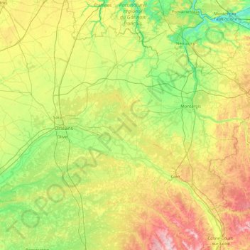
Name: Loiret topographic map, elevation, terrain.
Location: Loiret, Centro, Francia metropolitana, Francia (47.48306 1.51220 48.34495 3.12864)
Average elevation: 135 m
Minimum elevation: 43 m
Maximum elevation: 361 m
Other topographic maps
Click on a map to view its topography, its elevation and its terrain.
Nogent-le-Rotrou
Francia > Centro > Nogent-le-Rotrou
Nogent-le-Rotrou, Eure-y-Loir, Centro, Francia metropolitana, 28400, Francia
Average elevation: 144 m
Mignerette
Francia > Centro > Mignerette
Mignerette, Montargis, Loiret, Centro, Francia metropolitana, 45490, Francia
Average elevation: 85 m
Châteauroux
Francia > Centro > Châteauroux
Châteauroux, Indre, Centro, Francia metropolitana, 36000, Francia
Average elevation: 154 m
Bérou-la-Mulotière
Francia > Centro > Bérou-la-Mulotière
Bérou-la-Mulotière, Dreux, Eure-y-Loir, Centro, Francia metropolitana, 28270, Francia
Average elevation: 164 m