
Make a donation
The Dalles topographic map
Click on the map to display elevation.
Make a donation
The Dalles
As in the summer, winter temperatures can vary tremendously from one day to the next. During arctic air events the daytime high temperatures will generally be well below 32 °F or 0 °C, while a strong subtropical push can raise temperatures into the 50s and low 60s F, even in January. It is quite common for relatively cold air to become trapped at low elevations due to an inversion above; depending on the temperature of the surface airmass, depth of the inversion layer, and temperatures above the inversion layer, this can result in snow, sleet, freezing rain or a very cold liquid rain.
Make a donation
About this map
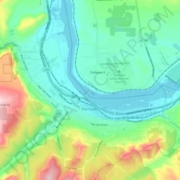
Name: The Dalles topographic map, elevation, terrain.
Location: The Dalles, Wasco County, Oregon, 97058, United States (45.58517 -121.22910 45.64030 -121.12104)
Average elevation: 105 m
Minimum elevation: 18 m
Maximum elevation: 343 m
Make a donation
Other topographic maps
Click on a map to view its topography, its elevation and its terrain.