
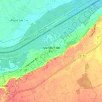
Kirchdorf am Inn topographic map
Interactive map
Click on the map to display elevation.
About this map
Name: Kirchdorf am Inn topographic map, elevation, terrain.
Average elevation: 344 m
Minimum elevation: 319 m
Maximum elevation: 374 m
Kirchdorf am Inn liegt auf 335 m Höhe im Innviertel. Die Ausdehnung beträgt von Nord nach Süd 5,1 km, von West nach Ost 5,1 km. Die Gesamtfläche beträgt 14 km². 7,1 % der Fläche sind bewaldet, 61,4 % der Fläche sind landwirtschaftlich genutzt.
Other topographic maps
Click on a map to view its topography, its elevation and its terrain.
Schalchham
Österreich > Oberösterreich > Bezirk Ried im Innkreis > Mörschwang
Schalchham, Mörschwang, Bezirk Ried im Innkreis, Oberösterreich, 4982, Österreich
Average elevation: 358 m
Steitzing
Österreich > Oberösterreich > Bezirk Ried im Innkreis > Waldzell
Steitzing, Waldzell, Bezirk Ried im Innkreis, Oberösterreich, 4924, Österreich
Average elevation: 555 m
Waldzell
Österreich > Oberösterreich > Bezirk Ried im Innkreis
Waldzell, Bezirk Ried im Innkreis, Oberösterreich, 4924, Österreich
Average elevation: 603 m