
Gauja / Koiva jõgi topographic map
Interactive map
Click on the map to display elevation.
About this map
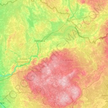
Name: Gauja / Koiva jõgi topographic map, elevation, terrain.
Location: Gauja / Koiva jõgi, Raunas novads, Vidzeme, LV-4125, Letland (57.06663 24.26505 57.70536 26.57436)
Average elevation: 102 m
Minimum elevation: 9 m
Maximum elevation: 286 m
Other topographic maps
Click on a map to view its topography, its elevation and its terrain.
Carnikavas novads
Carnikavas novads, Vidzeme, LV-2163, Letland
Average elevation: 5 m
Brantu dzirnavezers
Letland > Vidzeme > Raunas pagasts
Brantu dzirnavezers, Smiltenes iela, Bormaņi 1, Raunas pagasts, Raunas novads, Vidzeme, LV-4131, Letland
Average elevation: 191 m