
Allersberg topographic map
Interactive map
Click on the map to display elevation.
About this map
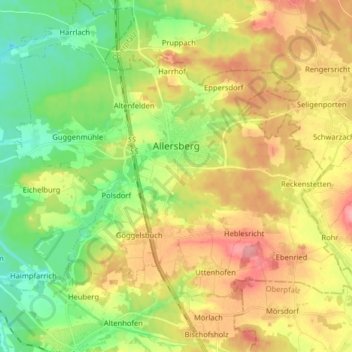
Name: Allersberg topographic map, elevation, terrain.
Location: Allersberg, Landkreis Roth, Beieren, 90584, Duitsland (49.20257 11.16195 49.28196 11.32229)
Average elevation: 406 m
Minimum elevation: 349 m
Maximum elevation: 478 m
Other topographic maps
Click on a map to view its topography, its elevation and its terrain.
Greding
Duitsland > Beieren > Landkreis Roth > Greding
Greding, Landkreis Roth, Beieren, 91171, Duitsland
Average elevation: 488 m
Enderndorf am See
Duitsland > Beieren > Landkreis Roth > Spalt > Enderndorf am See
Enderndorf am See, Spalt, Landkreis Roth, Beieren, 91174, Duitsland
Average elevation: 442 m