
Thank you for supporting this site ❤️
Make a donation
Make a donation
Bramhanwel topographic map
Click on the map to display elevation.
Thank you for supporting this site ❤️
Make a donation
Make a donation
About this map
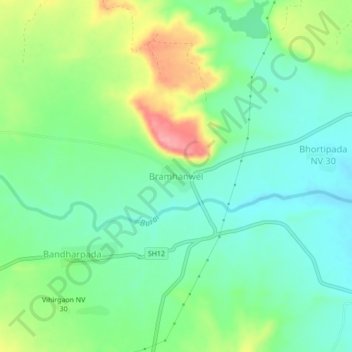
Name: Bramhanwel topographic map, elevation, terrain.
Location: Bramhanwel, Sakri Taluka, Dhule District, Maharashtra, India (21.13340 74.18518 21.17340 74.22518)
Average elevation: 532 m
Minimum elevation: 496 m
Maximum elevation: 605 m
Thank you for supporting this site ❤️
Make a donation
Make a donation