
Palangka Raya topographic map
Interactive map
Click on the map to display elevation.
About this map
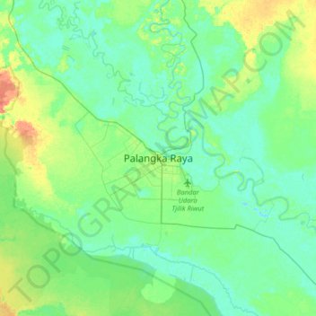
Name: Palangka Raya topographic map, elevation, terrain.
Location: Palangka Raya, Central Kalimantan, 73112, Indonesia (-2.36729 113.75644 -2.04729 114.07644)
Average elevation: 10 m
Minimum elevation: -3 m
Maximum elevation: 35 m
Palangka Raya borders Gunung Mas Regency to the north, Katingan Regency to the west, and Pulang Pisau Regency to the south and east. The area's soil consists mostly of peat and alluvium in its southern part and podzol on the northern part of the city. Overall, podzol soil dominates the city soil with 218,486 out of 285,349 hectares of city's landscape. Most of the city's topography is flat, with a general slope of less than 40 percent. Palangka Raya is mostly located around 35 meters above sea level.
Other topographic maps
Click on a map to view its topography, its elevation and its terrain.
Palangka Raya
Indonesia > Central Kalimantan
Palangka Raya, Central Kalimantan, Kalimantan, Indonesia
Average elevation: 23 m
Lamandau
Indonesia > Central Kalimantan
Lamandau, Central Kalimantan, Kalimantan, Indonesia
Average elevation: 140 m
Barito Selatan
Indonesia > Central Kalimantan
Barito Selatan, Central Kalimantan, Kalimantan, 73711, Indonesia
Average elevation: 38 m
Pulang Pisau
Indonesia > Central Kalimantan
Pulang Pisau, Central Kalimantan, Kalimantan, 74811, Indonesia
Average elevation: 15 m
Sukamara
Indonesia > Central Kalimantan
Sukamara, Central Kalimantan, Kalimantan, Indonesia
Average elevation: 21 m
Murung Raya
Indonesia > Central Kalimantan
Murung Raya, Central Kalimantan, Kalimantan, Indonesia
Average elevation: 365 m
Palangka
Indonesia > Central Kalimantan > Palangka Raya
Palangka, Palangka Raya, Central Kalimantan, Kalimantan, 74874, Indonesia
Average elevation: 10 m
Katingan
Indonesia > Central Kalimantan
Katingan, Central Kalimantan, Kalimantan, Indonesia
Average elevation: 78 m
Kapuas
Indonesia > Central Kalimantan
Kapuas, Central Kalimantan, Kalimantan, Indonesia
Average elevation: 84 m
Barito Timur
Indonesia > Central Kalimantan
Barito Timur, Central Kalimantan, Kalimantan, 73652, Indonesia
Average elevation: 50 m
Seruyan
Indonesia > Central Kalimantan
Seruyan, Central Kalimantan, Kalimantan, Indonesia
Average elevation: 82 m
Kotawaringin Timur
Indonesia > Central Kalimantan
Kotawaringin Timur, Central Kalimantan, Kalimantan, Indonesia
Average elevation: 43 m
Kotawaringin Barat
Indonesia > Central Kalimantan
Kotawaringin Barat, Central Kalimantan, Kalimantan, Indonesia
Average elevation: 47 m
Gunung Mas
Indonesia > Central Kalimantan
Gunung Mas, Central Kalimantan, Kalimantan, Indonesia
Average elevation: 152 m
Barito Utara
Indonesia > Central Kalimantan
Barito Utara, Central Kalimantan, Kalimantan, Indonesia
Average elevation: 128 m
Sanggu
Indonesia > Central Kalimantan > Barito Selatan
Sanggu, Barito Selatan, Central Kalimantan, Kalimantan, 73711, Indonesia
Average elevation: 19 m
Suka Mandang
Indonesia > Central Kalimantan > Seruyan
Suka Mandang, Seruyan, Central Kalimantan, Kalimantan, Indonesia
Average elevation: 40 m
Pendahara
Indonesia > Central Kalimantan
Pendahara, Central Kalimantan, Indonesia
Average elevation: 25 m
Kasongan
Indonesia > Central Kalimantan
Kasongan, Central Kalimantan, Indonesia
Average elevation: 18 m
Bukit Raya
Indonesia > Central Kalimantan
Bukit Raya, Central Kalimantan, Kalimantan, Indonesia
Average elevation: 1,637 m
Pembuang Hulu I
Indonesia > Central Kalimantan
Pembuang Hulu I, Central Kalimantan, Indonesia
Average elevation: 21 m
Pahandut
Indonesia > Central Kalimantan
Pahandut, Central Kalimantan, 73111, Indonesia
Average elevation: 8 m
Tamiang Layang
Indonesia > Central Kalimantan
Tamiang Layang, Central Kalimantan, Indonesia
Average elevation: 22 m
Rawa Subur
Indonesia > Central Kalimantan
Rawa Subur, Central Kalimantan, Indonesia
Average elevation: 5 m
Gumpa
Indonesia > Central Kalimantan > Gumpa
Gumpa, Central Kalimantan, Indonesia
Average elevation: 46 m
Pangkalan Bun
Indonesia > Central Kalimantan > Kotawaringin Barat
Pangkalan Bun, Kotawaringin Barat, Central Kalimantan, Kalimantan, 74111, Indonesia
Average elevation: 9 m
Taman Semangat 45
Indonesia > Central Kalimantan > Sidorejo
Taman Semangat 45, Sidorejo, Central Kalimantan, Indonesia
Average elevation: 6 m
Kuala Kurun
Indonesia > Central Kalimantan > Kuala Kurun
Kuala Kurun, Central Kalimantan, Indonesia
Average elevation: 64 m
Tanjung Puting National Park
Indonesia > Central Kalimantan > Kumai Hulu > Kumai Seberang
Tanjung Puting National Park, Raya 3, Kumai Seberang, Kumai Hulu, Central Kalimantan, Indonesia
Average elevation: 8 m
Raja Seberang
Indonesia > Central Kalimantan > Raja Seberang
Raja Seberang, Central Kalimantan, 74111, Indonesia
Average elevation: 5 m
Tandjung Puting
Indonesia > Central Kalimantan
Tandjung Puting, Central Kalimantan, Indonesia
Average elevation: 1 m