
Thank you for supporting this site ❤️
Make a donation
Make a donation
Cintalapa topographic map
Click on the map to display elevation.
Thank you for supporting this site ❤️
Make a donation
Make a donation
About this map
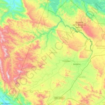
Name: Cintalapa topographic map, elevation, terrain.
Location: Cintalapa, Chiapas, Mexico (16.36609 -94.13916 17.13696 -93.55509)
Average elevation: 762 m
Minimum elevation: 49 m
Maximum elevation: 2,020 m
Thank you for supporting this site ❤️
Make a donation
Make a donation
Other topographic maps
Click on a map to view its topography, its elevation and its terrain.