
Thank you for supporting this site ❤️
Make a donation
Make a donation
Kiryandongo topographic map
Click on the map to display elevation.
Thank you for supporting this site ❤️
Make a donation
Make a donation
About this map
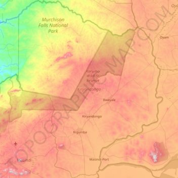
Name: Kiryandongo topographic map, elevation, terrain.
Location: Kiryandongo, Western Region, Uganda (1.61538 31.74900 2.37190 32.36291)
Average elevation: 1,022 m
Minimum elevation: 679 m
Maximum elevation: 1,375 m
Thank you for supporting this site ❤️
Make a donation
Make a donation