
Make a donation
Colmenarejo topographic map
Click on the map to display elevation.
Make a donation
About this map
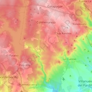
Name: Colmenarejo topographic map, elevation, terrain.
Location: Colmenarejo, Comunidade de Madrid, Espanha (40.48567 -4.05490 40.58417 -3.98445)
Average elevation: 805 m
Minimum elevation: 619 m
Maximum elevation: 932 m
Make a donation
Other topographic maps
Click on a map to view its topography, its elevation and its terrain.
Plaza de Toros
Espanha > Comunidade de Madrid > Las Vegas > Villarejo de Salvanés
Average elevation: 765 m
laponia
Espanha > Comunidade de Madrid > Área metropolitana de Madrid y Corredor del Henares > Madrid
Average elevation: 687 m
La Pesquera - El Pornoso
Espanha > Comunidade de Madrid > Sierra Norte > Bustarviejo > La Pesquera - El Pornoso
Average elevation: 1,258 m
Alcorcón
Espanha > Comunidade de Madrid > Área metropolitana de Madrid y Corredor del Henares > Alcorcón
Average elevation: 646 m
Make a donation