
Rochefort topographic map
Interactive map
Click on the map to display elevation.
About this map
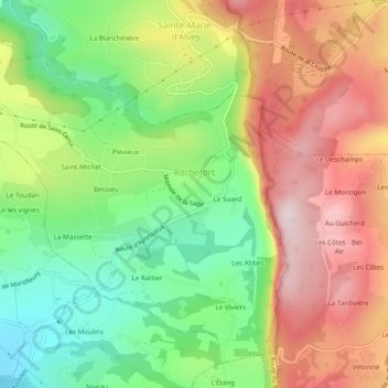
Name: Rochefort topographic map, elevation, terrain.
Average elevation: 465 m
Minimum elevation: 249 m
Maximum elevation: 709 m
Other topographic maps
Click on a map to view its topography, its elevation and its terrain.
Urice
France > Auvergne-Rhône-Alpes > Savoie > Rochefort
Urice, Rochefort, Chambéry, Savoie, Auvergne-Rhône-Alpes, France métropolitaine, 73240, France
Average elevation: 406 m