
Nikawatawana topographic map
Interactive map
Click on the map to display elevation.
About this map
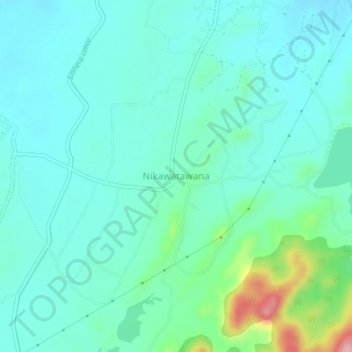
Name: Nikawatawana topographic map, elevation, terrain.
Location: Nikawatawana, Matale District, Central Province, Sri Lanka (7.85550 80.74956 7.89550 80.78956)
Average elevation: 228 m
Minimum elevation: 195 m
Maximum elevation: 364 m
Other topographic maps
Click on a map to view its topography, its elevation and its terrain.
upper division, north meddecombra
Sri Lanka > Central Province > upper division, north meddecombra
Average elevation: 1,268 m