
Thank you for supporting this site ❤️
Make a donation
Make a donation
Prenzlau topographic map
Click on the map to display elevation.
Thank you for supporting this site ❤️
Make a donation
Make a donation
About this map
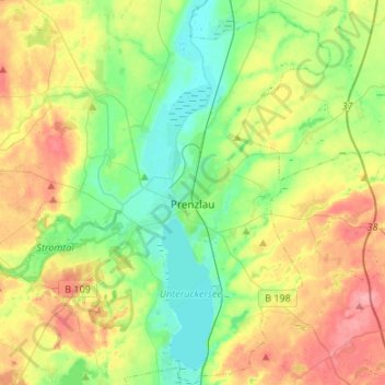
Name: Prenzlau topographic map, elevation, terrain.
Location: Prenzlau, Uckermark, Brandenburg, 17291, Germany (53.24140 13.75539 53.40144 13.96256)
Average elevation: 48 m
Minimum elevation: 13 m
Maximum elevation: 102 m
Thank you for supporting this site ❤️
Make a donation
Make a donation
Other topographic maps
Click on a map to view its topography, its elevation and its terrain.